
Trace a Loveland Street Directory by Address
The physical address is the first key, but it is only a starting label. Standardize the number, direction, street name, street type, unit, city, and ZIP. Loveland's Property Report can help when a county search needs the city's address format. The report and county addressing material also help distinguish a city address from an unincorporated Larimer County address.
The address chain should preserve the distinction between location, ownership, and history. A useful by-street note records the source, date, parcel key, legal description, and reason a nearby parcel was included. Follow the sequence below before interpreting a name as a resident.
- Confirm the physical address with the Larimer Land Information Locator, turn on parcels and addresses, and identify the target polygon.
- Use Larimer Assessor property search to save the parcel number, account number, situs address, subdivision, map number, tax year, and run date.
- Save owner fields and mailing fields separately. A mailing city or ZIP can differ from the physical Loveland situs.
- Carry the parcel, short legal description, current owner, or reception number into Landmark and inspect the deed party role.
- Use the Colorado voter form only for one person with first name, last name, ZIP, and birthday, and record a confidential or no-match result without guessing.
- For earlier occupants, move to the library's Street Guide, cross-reference volumes, telephone books, newspapers, Sanborn maps, and census records.
The Larimer parcel viewer shows why a Loveland street directory is a parcel-by-parcel exercise rather than a ready-made people roster.
The LIL map source supplies parcels, addresses, subdivisions, platted blocks and lots, sales from July 1, 2011, HOA, minerals, flood, recorded dimensions, and tools to Identify, Print, Export, or Share a view. It does not identify every occupant.
Loveland Parcel Search Fields
Larimer Assessor public data is most useful when its field names remain intact. The property search accepts an address, owner name, or parcel and account key. The downloadable files add the stable labels that connect a map result to a deed or a later review. Save the tax year and run date because a row is a dated extract, not an eternal statement of ownership.
| Field or group | Where it appears | What it contributes |
|---|---|---|
PARCELNO | Account and GIS crosswalk | Parcel identifier used to join public-data files and map results. |
ACCOUNTNO | Account file | Assessor account key for the property record. |
SCHEDULENUM | Account file | Schedule identifier that helps separate assessment records. |
SITUSADDRESS/CITY/ZIP | Account or owner-location data | Physical location of the parcel or building. |
MAILADDRESS/CITY/STATE/ZIP | Owner and owner-location data | Where assessor correspondence is directed, not the parcel location. |
SHORTLEGALDESCRIPTION | Account file | Bridge from street wording to a legal land description. |
SUBNO and SUBDIVISIONNAME | Account file | Subdivision context for plats and recorded instruments. |
MAPNO | Account and map files | Map reference for the parcel crosswalk. |
TAXYEAR and RUNDATE | Public-data extract | When the assessment row was current for that file. |
Sales fields such as RECEPTIONNO, GRANTOR, GRANTEE, SALEPRICE, SALEDATE, DEEDCODE, and DEEDDESCRIPTION are leads into the recording index. A sales row is not the deed image and the Assessor does not decide boundary disputes.
Street Directory Records in Loveland
Every address-keyed source adds a different layer to the Loveland by-street workflow. The table keeps the keeper and access route visible so a failed search can move to the next channel. A parcel map, permit record, deed index, historical listing, and voter report should never be merged simply because they share a street name.
| Record set | Keeper | Address clue | Access route |
|---|---|---|---|
| Assessor account and owner data | Larimer Assessor | Situs, mail, parcel, account, legal description | Property search and public-data files |
| GIS parcel and address layer | Larimer GIS | Polygon, nearby parcel, subdivision, lot or block | Public LIL map with Identify, Print, Export, Share |
| City Property Report | Loveland Planning | Zoning, plat, subdivision, city address files | Find Address and download report |
| Permit and inspection record | Loveland Building Division | Permit number, address, contractor, dates | CitizenAccess Public Access; request missing files |
| Deeds, liens, plats, easements | Larimer Clerk & Recorder | Legal description, grantor, grantee, reception number | Landmark 1971-present; older books at the office |
| Street Guide or cross-reference | Library and History Connection | Year-specific address-to-name entry | Scans, physical volumes, assisted research |
| Voter data and reports | Colorado SOS and Larimer Elections | Personal form fields or requested district report | One-person lookup or permitted data request |
| Recording Activity Notification | Larimer Clerk & Recorder | Recorded name match | Free email alert, not a street search |
Use the Assessor and LIL for the current parcel, Landmark for recorded parties, CitizenAccess for retained city files, and the library for historical occupants. The voter form belongs at the verification stage. It cannot fill the gaps left by a protected record or an unlisted household.
Loveland Permit History by Address
CitizenAccess is a useful second address layer. Choose Public Access in the upper-left navigation, choose Permits, and search with an address that has no punctuation or with a complete seven-digit application number and dash. The documented view can show permit status, contractor names, dates, structure specifications, valuations, fees, inspections, completed review comments, and retained plans, letters, applications, site plans, or certificates of occupancy.
Permit coverage depends on the construction year and the retained file. A contractor, inspector, applicant, or plan name is not automatically an owner or occupant. If the portal is empty, use the city's request-for-records form with the address, case type, and date range. Code Administration material is routed through Police Records. The Building Division at 410 E 5th Street is the local routing point for questions about the address-keyed file.
The Loveland Building Division page links that local routing point to permit workflow steps and the request path when a file needs direct review.
The Loveland CitizenAccess portal is best used to date a building change or verify a permit trail, not to create a resident list.
Landmark Deeds Along Loveland Streets
This by-street workflow becomes a deed trail when each parcel is searched by legal description or party. Landmark exposes name, document, book and page, consideration, record date, reception, and legal search modes. Quick choices include ownership, mortgages, released liens, liens and judgments, foreclosure, and all documents for a name. Search the current owner as a grantee around the likely purchase date, then follow the seller or grantor backward through the legal description.
Online indexing is available from 1971 to the present. Anonymous access gives index data, free registration gives watermarked images, and paid downloads provide unwatermarked images. Images cost $0.25 per page up to 8.5 by 14 inches or $2 for a larger page or plat. Certification adds $1 per document. Mail and phone orders should include the reception or CFN number, and posted processing is 72 hours.
The Larimer Landmark search is an index, not title insurance. The instrument's party role and legal description matter because a deed party may be a lender, trustee, spouse, executor, lien claimant, or beneficiary rather than a person living on the street.
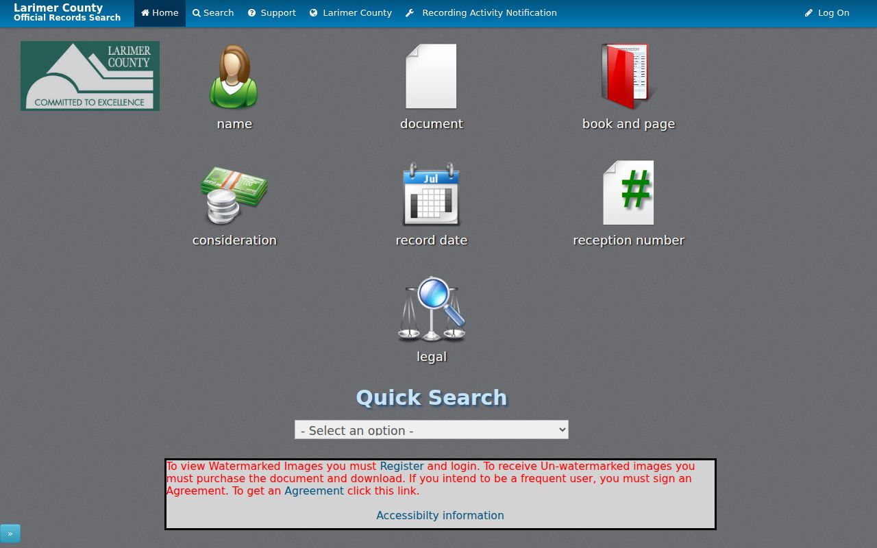
The Landmark source image shows the separate search modes that keep a street record tied to a reception number, document type, date, or legal term instead of an unverified name match.
Pre-1971 books require a search at 200 W Oak Street in Fort Collins. The county will not perform a custom search for the requester, so an older chain needs a book, page, legal description, or a narrow record question.
| Anonymous access | Free index data with party, document, date, reception, and legal-description fields. |
|---|---|
| Registered access | Free registration permits watermarked image viewing. |
| Paid download | Unwatermarked images at $0.25 per page up to 8.5 by 14 inches or $2 for a larger page or plat. |
| Certified or older book | Certification adds $1 per document; pre-1971 books use the Fort Collins office route, while mail or phone orders should include a reception or CFN number. |
Loveland Voter ZIP Is Personal
The state voter form asks for first name, last name, ZIP, and birthday. It can confirm a registration match under those fields, but it cannot browse a street or produce a complete Loveland residential workflow. Confidential voters and people under 18 may be absent. A missing match can be a privacy result, a changed ZIP, a spelling issue, or a person who is not registered at the tested address.
Larimer Elections handles permitted reports and data requests for precinct, district, party, active-cycle ballot status, or prior voting history. Reports exclude confidential voters and protected fields such as SSN and full birthday. A ward or precinct map supplies civic geography, not a list of occupants. For one person, save the form inputs and date; for a district, request the report whose scope matches the question.
The Colorado voter lookup form is therefore a verification step inside the street directory workflow, never the street browser itself.
Loveland City Address Files
Loveland's Property Report workflow is Find Address, choose the address, Select Address, run or download the report, and review City Address Files. The report can connect an address to zoning, agreements or reviews, subdivision and plat information, and city planning context. It is a city record layer, not a county tax card, deed, survey, or household file.
Address authority changes at the city and unincorporated-county line. Loveland assigns addresses inside the city, while Larimer County handles unincorporated areas. Private-drive naming and new-site questions belong with the addressing authority. Keep the city address, county situs, postal last line, and legal description together until the record keeper confirms which one it uses.
The Loveland Property Report instructions are the best local check when an address does not match a county search field.
Old Loveland Numbers Need Context
No verified citywide Loveland renumbering event was located. A mismatch can instead come from a directional abbreviation, a changed street type, annexation, rural-route conversion, alternate mailing label, or a deed that uses only a legal description. Do not publish a guessed change year. Check City Address Files, historic maps, plats, old directories, and the Clerk and Recorder's legal description.
Sanborn sheets for Loveland are documented for 1886, 1890, 1893, 1900, 1906, 1911, 1918, 1927, 1937, and 1946. They show building footprint, use, materials, and street context, not ownership or occupancy. A rural route in a 1925 directory can also describe a place later assigned a street address. That is why a legal description and parcel key are stronger continuity anchors than a copied number.
The Larimer addressing information provides the county and city split, naming rules, and the current route for suspected address changes.
What Loveland Streets Cannot Show
A street directory can connect public records to a place, but no complete public occupant list exists for Loveland. The Assessor lists ownership and mailing fields, not every household member. A voter report has confidentiality, under-18, report, and use limits. DMV records are restricted under the DPPA and Colorado law, and utility customer lists were not located as public resident sources.
A permit applicant, contractor, business address, registered agent, lender, trustee, or deed party may have a different connection to the property. An HOA layer or planning notice shows an association or project geography, not a member roster. RAN watches a name, not a street. Treat each result as a source-specific fact and avoid combining partial records into a private profile.
- Parcel
- A mapped legal land unit with a parcel number, not a list of the people who use it.
- Situs address
- The physical location tied to the parcel, Assessor, GIS, permits, and city property report.
- Plat
- A recorded map that lays out lots, blocks, streets, or other land divisions.
- Criss-cross directory
- A historical address-order directory that can link a street or house number to a listed name for a particular year.
Privacy limit. Loveland address records support lawful personal research, family history, and civic questions. Using a public address to stalk, threaten, follow, intimidate, or harass someone can violate Colorado stalking statute C.R.S. §18-3-602 or harassment statute C.R.S. §18-9-111.
RAN Watches Loveland Names
Larimer's Recording Activity Notification is a free email alert for a matching recorded name. It can help a property owner notice a new recording, but it does not search every document for a street and does not replace a deed review. A name alert may match a different person, so the reception number and legal description still need to be checked in Landmark.
Property-record scams often use a public-looking notice and an urgent payment demand. Larimer warns that a property protest or property record does not require payment to a private solicitor. Verify a mailer through the county's official portal, preserve the envelope and reception number, and use the Sheriff's fraud guidance or law-enforcement route when a deed or title fraud is suspected.
The Larimer Clerk and Recorder information is the official entry point for RAN and recording contacts.
Four Loveland Wards on Maps
Loveland has four wards with two council members each. The April 4, 2023 redistricting followed the 2020 Census imbalance and tried to use roads, neighborhoods, water, and rail lines as natural breaks. A ward can help explain a public project or council record connected to an address, but it is not a complete street record and does not show every nearby household.
Planning notices can add another boundary clue. A qualifying annexation, rezoning, or development proposal may use a 500-foot mailing radius and right-of-way signs. Pair that project geography with LIL parcels, the City Property Report, and the address date. ZIP, ward, precinct, HOA, metro district, parcel, and city-limit lines overlap without becoming interchangeable.
The Loveland ward information helps place a street in the civic map while keeping the boundary separate from a residents directory.